Monday, November 2, 2009

Ride the Choo-Choo!

Bright and early we boarded the Great Smoky Mountain Railroad in Bryson City, NC for the Nantahala Gorge excursion. It was a wonderful 4.5 hour ride that went along the Tuckasegee river and over the Fontana lake tressel. There was an hour stop in the Nantahala Outdoor Center. Unfortunately, there were no tunnels on this leg of the train tracks (Joseph looked for one and asked a few times 'Go Tunnel?')

The windows opened and we were free to move around on the train. Joseph loved hanging his head out the window and visiting the open cars.

The Great Smoky Mountains NP and surrounding areas

We climbed up Clingmans Dome which at 6,643 feet is Great Smoky Mountains National Park's highest point. It is the highest point in Tennessee.

After walking a paved (but steep) half-mile trail there was a 54-foot observation tower. From which you can see to NC, TN, SC and GA! We had a wonderful sunny clear day and enjoyed the fabulous view before continuing on to Gatlinburg, TN.

The leaves in TN were much more spectacular than NC. While in Gatlinburg we took the aerial tram to the ski resort where we rode the Scenic Chairlift to get a good view of the fall leave colors and also rode the Alpine Slide. Unfortunately, Joe and I went behind a slow lady and her slower son and half of our alpine slide ride was braking so we didn't run into the pokey people ahead of us. But the leaves were very colorful!

Bridal Veil and Dry Falls

On our first day out in western NC it was rainy and overcast. We decided to drive to see a few waterfalls. Three of them were viewable only as you drove by and we didn't get any pictures...

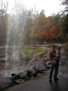
Bridal veil falls is a waterfall that you can drive your car under and stand under for some photo oportunities.

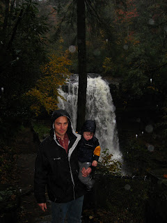
Ironically, Dry Falls was a very wet hike for us. It was pouring down rain but we made the short hike to go under the falls. Dry falls (like Bridal Veil) allows you to stand under it and look out at the falls.

On our drive back to the cabin we were staying in we decided to use the GPS directions to get home (it was 15 minutes shorter than the roads we had taken to get to the falls)...

Well, we'll share our experience so others don't make the same mistake. Don't trust a GPS to get you around in Western NC, unless you drive a 4WD vehicle. We had driven about 8 miles down a 'road' that wasn't paved and snaked up one side of a mountain and down the other only to find a washed out portion only minutes from our destination. Joe waded into the stream to check the depth (MUCH too deep for a sedan), and we ended up turning around and driving another hour to get back to the cabin! The GPS failed us twice on our trip, the second time taking us to an underpass and telling us to turn left onto the highway above...

The North Carolina State Fair